Back in 1967 I was in a typhoon when I was in the Philippines, the eye went right over us so we had about 30 hours of the front of the storm hitting us then about 6 hours of total calm, not a breeze then the back side of the storm for another 30 hours, then the next three days everybody was on cleanup. I was in another one when in Okinawa, but the eye was well off of us, we broke out the K rations, the cards, the booze and had a party for a couple days, then like in the Philippines, we were all on clean up.
There was a second one that hit Okinawa but I was in Bangkok at the time so missed that one, however I was there for 4 + months through the monsoon season, it rained 3 to 5 inches every day between 2 and 4 for about 30 minutes, then all evaporated over the next hour, (steam cleaned) we were.
River
There's Always The Weather
-
Riverwind (imported)
- Articles: 0
- Posts: 7558
- Joined: Sun Dec 30, 2001 1:58 pm
-
Posting Rank
-
Dave (imported)
- Articles: 0
- Posts: 6386
- Joined: Tue Dec 04, 2001 6:06 pm
-
Posting Rank
Re: There's Always The Weather
>>I think that what scares Manhattan and the rest of New York City (the other 4 boroughs) is that storm surge.
>>Think of high tide and then add 5 to 9 feet to it.
>>MOI said it might be like "The Day After Tomorrow" and although that exaggerates the surge, I can't fault the image.
>>Think of what happens as water flows from the statue of liberty up the Hudson River, up into Passaic and Elizabeth and over Jones Beach and water flows AROUND Long Island and into Long Island Sound from the other direction.
>>Where does all that water go...
>>
>>
Paul Douglas's Huffington Post update (lots of nice pictures I can't bring over)
Why Aren't Officials Evacuating Low-Lying Boroughs Of New York? NOAA Slosh models have been consistent, showing a 10 foot rise in water levels, focused in Long Island Sound, Monday afternoon and evening - at the height of the storm, as Sandy tracks south of Long Island and New York City, the combination of winds and waves allowing water to pile up from coastal New Jersey to the New York Bight/New York Harbor to JFK and LGA (which I expect to be partially under water).
Maybe they don't believe the meteorologists - perhaps they can't comprehend that a hurricane-like storm can strike a couple days before Halloween? Maybe they're getting conflicting information and forecasts - and paralyzed into taking action? I don't know, but I'm increasingly worried about the implications of their inaction. By the time they decide to move people living/working within 5-8 feet of sea level it may be too late. Conditions will rapidly deteriorate tonight, with the worst of the storm tomorrow into early Tuesday morning - I suspect the highest storm surge will come Monday afternoon/evening, around the time of the full moon.
MTA Shutting Down New York City Ground Transportation This Evening. Latest from Huffington Post. All subway, commuter rail and bus service shuts down as of 7 pm this evening. That's a good first step, but New York City officials need to be moving people away from sea level. Now.
>>Think of high tide and then add 5 to 9 feet to it.
>>MOI said it might be like "The Day After Tomorrow" and although that exaggerates the surge, I can't fault the image.
>>Think of what happens as water flows from the statue of liberty up the Hudson River, up into Passaic and Elizabeth and over Jones Beach and water flows AROUND Long Island and into Long Island Sound from the other direction.
>>Where does all that water go...
>>
>>
Paul Douglas's Huffington Post update (lots of nice pictures I can't bring over)
Dave (imported) wrote: Sat Oct 27, 2012 3:54 pm http://www.huffingtonpost.com/paul-doug ... 17644.html
Why Aren't Officials Evacuating Low-Lying Boroughs Of New York? NOAA Slosh models have been consistent, showing a 10 foot rise in water levels, focused in Long Island Sound, Monday afternoon and evening - at the height of the storm, as Sandy tracks south of Long Island and New York City, the combination of winds and waves allowing water to pile up from coastal New Jersey to the New York Bight/New York Harbor to JFK and LGA (which I expect to be partially under water).
Maybe they don't believe the meteorologists - perhaps they can't comprehend that a hurricane-like storm can strike a couple days before Halloween? Maybe they're getting conflicting information and forecasts - and paralyzed into taking action? I don't know, but I'm increasingly worried about the implications of their inaction. By the time they decide to move people living/working within 5-8 feet of sea level it may be too late. Conditions will rapidly deteriorate tonight, with the worst of the storm tomorrow into early Tuesday morning - I suspect the highest storm surge will come Monday afternoon/evening, around the time of the full moon.
MTA Shutting Down New York City Ground Transportation This Evening. Latest from Huffington Post. All subway, commuter rail and bus service shuts down as of 7 pm this evening. That's a good first step, but New York City officials need to be moving people away from sea level. Now.
-
cheetaking243 (imported)
- Articles: 0
- Posts: 422
- Joined: Sun Jul 10, 2011 8:35 pm
-
Posting Rank
Re: There's Always The Weather
Really dire news out of the latest runs of forecast models. This just keeps getting worse and worse. First of all, overnight the pressure of Sandy has dropped another 10 mb, and is now down to 951 mb. Also the wind field has nearly doubled again. Hurricane-force winds are now extending up to 175 miles from the center
Dr. Jeff Masters just upgraded his chance of the New York subway system flooding from 30% to 50%. People anywhere in the area, and anywhere close to the shore, this is no joke. You are staring down the face of the highest storm surge EVER reported in the area.
s up to 520 miles from the center. But the worst part is this: Remember how I said last night that Sandy's winds were being rated a 2/
but the storm surge was being rated a massive 5.2/6 on the potential-damage scale? Well, NOAA just released new numbers. The potential for wind damage has been raised to a 2.6/6 on the scale, which still isn't that bad, but the storm surge damage potential has been raised to an unbelievable 5.7/6. This number is higher than ANY hurricane observed between 1969 and 2005, including category-5 hurricanes Katrina, Rita, Wilma, Isabel, Andrew, and Camille. I repeat, this storm's surge has greater damage potential than a CATEGORY 5 HURRICANE. A storm surge of up to 11 feet is expected from northern New Jersey through the Long Island sound, including the New York City harbor.
Dr. Jeff Masters just upgraded his chance of the New York subway system flooding from 30% to 50%. People anywhere in the area, and anywhere close to the shore, this is no joke. You are staring down the face of the highest storm surge EVER reported in the area.
-
cheetaking243 (imported)
- Articles: 0
- Posts: 422
- Joined: Sun Jul 10, 2011 8:35 pm
-
Posting Rank
Re: There's Always The Weather
Update: Sandy's storm surge potential has just been upgraded AGAIN, and is now at an unprecedented 5.8/6 on the Powell scale. This is the highest number on record. As in, not a single other hurricane has EVER made it this high on the scale. The previous record was 5.7, during Hurricane Isabel of 2003, which breached a North Carolina barrier island upon landfall. 2nd place was previously held by 2008's
This is scary as hell... I'm now starting to seriously fear for my uncle, who lives within two miles of the north Jersey shore.
Here are some photos of what Isabel's storm surge did to the North Carolina and Virginia coast back in 2003. Sandy
http://earthobservatory.nasa.gov/Featur ... 030921.jpg (by far the worst)
http://ccrm.vims.edu/cara_web/Cara%20im ... 2picch.jpg
http://www.city-data.com/disaster-photo ... s/8411.jpg
http://ccrm.vims.edu/cara_web/Cara%20im ... ldozch.jpg
http://www.vdare.com/images/TLVDARE2.jpg
http://mw2.google.com/mw-panoramio/phot ... 094379.jpg
http://worldonline.media.clients.elling ... L_t440.jpg
http://upload.wikimedia.org/wikipedia/c ... Isabel.JPG (Hatteras Island, before and after.)
entire Bolivar peninsula. Sandy now has surpassed both of these historic storms on this scale, and as such has the highest storm surge rating of ANY hurricane in the history of modern American meteorology. This is the kind of storm that has the potential to re-shape the entire shoreline, and erase entire portions of barrier islands.
This is scary as hell... I'm now starting to seriously fear for my uncle, who lives within two miles of the north Jersey shore.
Here are some photos of what Isabel's storm surge did to the North Carolina and Virginia coast back in 2003. Sandy
for the heavily-populated Jersey shore, southern Long Island, and the New York sound.
http://earthobservatory.nasa.gov/Featur ... 030921.jpg (by far the worst)
http://ccrm.vims.edu/cara_web/Cara%20im ... 2picch.jpg
http://www.city-data.com/disaster-photo ... s/8411.jpg
http://ccrm.vims.edu/cara_web/Cara%20im ... ldozch.jpg
http://www.vdare.com/images/TLVDARE2.jpg
http://mw2.google.com/mw-panoramio/phot ... 094379.jpg
http://worldonline.media.clients.elling ... L_t440.jpg
http://upload.wikimedia.org/wikipedia/c ... Isabel.JPG (Hatteras Island, before and after.)
-
moi621 (imported)
- Articles: 0
- Posts: 4434
- Joined: Sat Jan 19, 2008 6:23 pm
-
Posting Rank
Re: There's Always The Weather
Bob3 check in
Bob3 check in
<static noise>
Come in Bob3
<static noise>
Morristown, N.J. Anyone else in it?
Ohio is the wrong side of Appalachia.
It is a lovely, cozy day here. Not an uncomfortable Santa Ana condition.
Especially after the horrible humid summer that has left all my citrus trees with leaf wilt of the newest leaves.
I've seen it before, it sets the trees back a year or so.
I like Autumn. It is the best. Worth waiting through Late Winter, Spring and over lite Summers.

BTW the new episode of Boardwalk Empire was on as scheduled.
How bad can the storm be.
Bob3 check in
<static noise>
Come in Bob3
<static noise>
Morristown, N.J. Anyone else in it?
Ohio is the wrong side of Appalachia.
It is a lovely, cozy day here. Not an uncomfortable Santa Ana condition.
Especially after the horrible humid summer that has left all my citrus trees with leaf wilt of the newest leaves.
I've seen it before, it sets the trees back a year or so.
I like Autumn. It is the best. Worth waiting through Late Winter, Spring and over lite Summers.
BTW the new episode of Boardwalk Empire was on as scheduled.
How bad can the storm be.

-
bobover3 (imported)
- Articles: 0
- Posts: 893
- Joined: Sat Nov 08, 2008 12:39 am
-
Posting Rank
Re: There's Always The Weather
I'm obsessing over tracking maps of the storm. The probable heart of the storm is a couple hundred miles south of me, but there's still a chance that my town will be a direct target. If I'm spared trouble, it means trouble for others. What a predicament. Of course, it takes only one tree to knock out the power supply, and 75 MPH winds are still expected Monday night.
-
moi621 (imported)
- Articles: 0
- Posts: 4434
- Joined: Sat Jan 19, 2008 6:23 pm
-
Posting Rank
Re: There's Always The Weather
WE know you are there and will give us first person, present tense reports and not rely on the Obama Administration's maps so much.
Think of "Byrd spent five winter months alone operating a meteorological station" in Antarctica, or
Issac Cline and the great hurricane that devastated Galveston, TequHaas.
You are all EA has in the storm path.
Keep those reports coming.
And if things really look bad, remember Ernest Shackleton and Apollo 13.
Bon esprit
I envy you your storm but not the inconvenience.
Try enjoy the "elements".
I love a storm at the oceans edge but too often the authorities won't let you in sight of the waves.
Dress appropriately and venture out for a storm walk.
Beware of the attack of the virus 8-10 days after the storm. It is seeded 2-4 days after.
Avoid atmospheric germ pools.
G'luck.
Dave, you should be picking up some of that Nor'ester by now, aren't you?
The part that is coming cold from the Northlands. Planning to meet up with Sandy.
Moi
(Pacific) West Is Best
I guess the Northridge Earthquake taking out some major freeway over passes and the Oakland Earthquake taking out one of the San Francisco Bay bridges is about the largest scale catastrophes I can remember effecting via inconvenience the most people. The Pacific West keeps its' catastrophes better confined to affect the fewest people, unless they are all packed into San Francisco when the gas lines rupture. The real cause of the most devastation from the 1906 E'quake.
Notice I said Pacific West to exclude those fires around Colorado.
-
Dave (imported)
- Articles: 0
- Posts: 6386
- Joined: Tue Dec 04, 2001 6:06 pm
-
Posting Rank
Re: There's Always The Weather
Well according to the Weather Channel, the storm is still 950 millibar and there is an eye wall forming (it's 3/4's complete). That's signs of strengthening. It's turning north from its northeast path. The jet stream is pulling it north and sucking it onto the land.
I would say that they weather authorities backed a bit on the rainfall (they have) but that says nothing about the winds. Less rainfall would mean less inland flooding.
The greatest storm and tidal surge will hit Long Island Sound and not New York Harbor.
I might also say that the track seems to be southern New Jersey but this thing is so big and so spread out that doesn't make a difference. In fact, it's monstrous. They are predicting Philadelphia will get 50 mph winds.
WE had a twice a year fire drill where I worked and after a few times being hauled up and down stairs in either my wheelchair or the special emergency chair (neat gadget, really, comfortable and quite safe) I asked a coworker to give me word of the drills (he was in the volunteer fire company and always got the word of a drill) and then I would sneak down to the first floor and hide out until the drill was called then suddenly appear.
Perhaps you should find a way to be on ground level with your machines and then like my drills, if the power never goes out, so what. It's better than being hauled down stairs and all that.
-
Riverwind (imported)
- Articles: 0
- Posts: 7558
- Joined: Sun Dec 30, 2001 1:58 pm
-
Posting Rank
Re: There's Always The Weather
Yesterday I had my TV tuned to Fox Sports, Football then the fourth game of the World Series, I am not a base ball fan however I lived in the bay area for 30 years so a couple weeks ago I turned on the 5th game of the NLS St Louis only needed one more win, the Giants closed them out, the seventh game ended in a downpour then off to the World Series, I gotta say this was a fun team to watch, there was not any single hero but a complete team and they dominated the Tigers. Last night in 10 innings. The game was in a light mist all game and the wind picked up, big wind.
Today I will stay tuned to the weather channel,
Bob stay safe.
And anybody else on the east coast buckle down it going to be a bumpy ride.
River
Today I will stay tuned to the weather channel,
Bob stay safe.
And anybody else on the east coast buckle down it going to be a bumpy ride.
River
-
cheetaking243 (imported)
- Articles: 0
- Posts: 422
- Joined: Sun Jul 10, 2011 8:35 pm
-
Posting Rank
Re: There's Always The Weather
Update: overnight, Sandy has strengthened yet again. Its pressure has dropped another 6 mb, now down to 945 officially, with a possible decrease to a number as low as 939.1 at the 11 am update based on the last pass through the center by the hurricane hunter reconnaissance aircraft. (The numbers they have been reporting have been dropping like crazy in the last hour or so.) Also, the maximum sustained winds have now increased to 85 mph, with a possible increase to somewhere between 90-100 mph on the 11 am update based on a significant amount of new data that just arrived from the hurricane hunters. The only good news right now is that the storm has actually shrunk a little since the last update, with tropical-storm-force winds now extending 485 miles from the center instead of 520 miles.
The bad news is that the water-level rise in Battery Park, NYC, was about 6 inches higher during its morning tidal peak than was predicted. And as such the predicted storm tide for 9:00 tonight has now been increased to 11'. This raises the likelihood even more that the New York subway system will be flooded, which again could be up to a $50 billion economic disaster if it happens, cutting off both transportation and power to lower Manhattan since their entire power grid is underground.
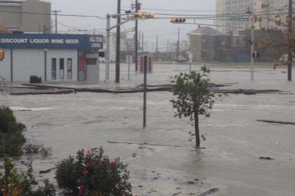
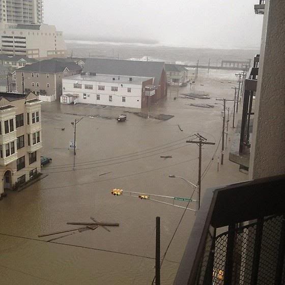
Storm tides on the Jersey shoreline are now predicted to be as high as 13 ft, since Sandy will be hitting directly at the lunar high tide. Odds are that most of the Jersey shoreline will be underwater. Parts of it already are, as they are currently experiencing the pre-storm high-tide peak. Here are two pictures taken minutes ago at the Atlantic City boardwalk. Odds are that most of the New Jersey coastline looks like this right now. http://i1234.photobucket.com/albums/ff4 ... iccity.png http://i1234.photobucket.com/albums/ff4 ... city-1.jpg And if you're interested in a live look at what Sandy is doing to the coast, here is a live camera of Ocean City, MD. http://fagers.com/sandycams.html (and again, Sandy has not made landfall yet. The water is supposed to come up another 2 or 3 feet by 9:00 tonight.
Early this morning, Sandy sunk the replica of the HMS Bounty which was used for the 1962 film, off the coast of North Carolina. 14 members of the crew were rescued from a life raft, 2 crew members are still unaccounted for.
Also, a buoy just off the coast of New Jersey, a hundred miles or so north of the center, just reported a 125 mph wind gust and sustained winds of 94 mph.
The bad news is that the water-level rise in Battery Park, NYC, was about 6 inches higher during its morning tidal peak than was predicted. And as such the predicted storm tide for 9:00 tonight has now been increased to 11'. This raises the likelihood even more that the New York subway system will be flooded, which again could be up to a $50 billion economic disaster if it happens, cutting off both transportation and power to lower Manhattan since their entire power grid is underground.
Storm tides on the Jersey shoreline are now predicted to be as high as 13 ft, since Sandy will be hitting directly at the lunar high tide. Odds are that most of the Jersey shoreline will be underwater. Parts of it already are, as they are currently experiencing the pre-storm high-tide peak. Here are two pictures taken minutes ago at the Atlantic City boardwalk. Odds are that most of the New Jersey coastline looks like this right now. http://i1234.photobucket.com/albums/ff4 ... iccity.png http://i1234.photobucket.com/albums/ff4 ... city-1.jpg And if you're interested in a live look at what Sandy is doing to the coast, here is a live camera of Ocean City, MD. http://fagers.com/sandycams.html (and again, Sandy has not made landfall yet. The water is supposed to come up another 2 or 3 feet by 9:00 tonight.
Early this morning, Sandy sunk the replica of the HMS Bounty which was used for the 1962 film, off the coast of North Carolina. 14 members of the crew were rescued from a life raft, 2 crew members are still unaccounted for.
Also, a buoy just off the coast of New Jersey, a hundred miles or so north of the center, just reported a 125 mph wind gust and sustained winds of 94 mph.